Eye on the Arctic

This past summer I had the privilege of exhibiting my work Sagalands at Forillon National Park as part of the Recontres internationales de la photographie en Gaspesie. The exhibition featured an outdoor photography installation at la Grande Grave and a video installation in an WWII bunker at Fort Peninsule. You can hear more about these projects and the exhibition in an interview with Radio Canada International on their program Eye on the Arctic.

http://www.rcinet.ca/eye-on-the-arctic/2015/07/27/feature-interview-canadian-artist-explores-greenlands-past/

Saga lands_Gaspe2_1500

Sagalands at La Grande Grave, Forillon National Park, Gaspésie

Still Ruins_Gaspe8_1500

Still Ruins, Moving Stones at Fort Peninsule, Forillon National Park, Gaspésie

000074940026

Artist presentation during the Rencontres internationales de la photographie a Gaspésie. Photo by Corinna Mehl.


The archeological eye – an artist’s excavation of L’Anse aux Meadows

The following is an excerpt from my presentation at the AASSC (Association for the Advancement of  Scandinavian Studies in Canada) conference at Ottawa University on June 2nd, 2015.

In my attempt to re-trace the steps of the Viking explorers that discovered the New World, I’ve travelled from the island of Gotland in Sweden working my way north-westward through Iceland and Greenland, photographing archeological sites and saga sites throughout Scandinavia. I wanted to learn as much as possible through first hand experience and personal observations. And like all great histories, my research raised more questions than provide answers.

Eriksstadir 001

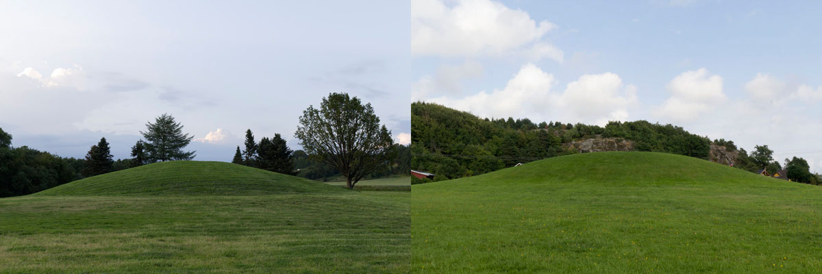
Eriksstadir, Dalir, Iceland

In the Dales region of Iceland, where archeologists have excavated the presumed site of Erik the Red’s farmstead, the modestly sized floor plan of a turf hut marks the beginning of the Vinland Sagas. Standing here I thought to myself, had Erik the Red had not clashed with his neighbors precipitating his own exile, would Greenland have ever become a significant Norse settlement? Had the Vikings not colonized Greenland, would they have discovered Vinland? This line of questioning prompted a metaphysical approach. I studied the landscape– it’s properties, sense of space, the climate, and change over time. These observations progressed into more abstract ways of thinking as I noted the subjective qualities that these sites impressed upon me.

Thingvellir rescan 001

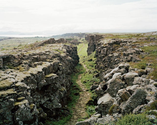
Continental Rift, Thingvellir, Iceland

From my own imaginative perspective, I believed it was no coincidence that the Norse stumbled upon North America via Iceland and Greenland. The continental rift that divides North America from Europe cuts across Iceland – the very chasm that Iceland’s settlers chose to establish their open-air parliament. Could they have already sensed that they were living on the threshold of a whole new world?

During the summer of 2014, seven years after my first visit, I once again found myself at the Northern tip of Newfoundland. This time I was equipped with the knowledge gained from years of research and observation, as well as a 4k high definition video camera and a small camera crew, ready to perform what I call a sensory excavation of the elusive L’Anse aux Meadows.

10405633_10154408259395007_7352431121874390743_n

On site at L’Anse aux Meadows National Historic Site, Newfoundland and Labrador. Filmed with the permission of the Parks Canada Agency.

My preoccupation with archeology is not uncommon within the realm of photographic art. The areas where landscape and photography meet often recall notions of history, memory, identity and experience. Artist’s fascination with the prehistoric was made apparent with the rise of the conceptual and Land Art movement throughout the 60’s and 70’s but lately a focus on archeology within the field of contemporary art is on the rise. Proposing that a preoccupation with archeology was one of the dominant trends in contemporary art, a recent exhibition presented at the Museum of Contemporary Art Chicago titled “Way of the Shovel: Art as Archeology” presented works from some of today’s leading artists, reflecting their interests in history, archaeology and archival research. Largely composed of lens-based works (photography and video), the exhibition in someway refers the familiar TV network known as The History Channel. The artworks however, express a greater concern for remembering histories, challenging notions of truth and reflecting upon the process of excavating, rather than presenting any material as evidence, scientific or otherwise.

Jeff Wall Excavation

Jeff Wall: Fieldwork. Excavation of the floor of a dwelling in the former Sto:lo nation village, Greenwood Island, Hope, B.C., August, 2003, Anthony Graesch, Dept. of Anthropology, University of California at Los Angeles, working with Riley Lewis of the Sto:lo band, 2003. Transparency in lightbox, 219.5 x 283.5 cm

Perhaps this sense of curiosity and imagination was the driving force behind Helge Ingstad’s expeditions to find the place from the Sagas known as Vinland. A Norwegian explorer, Ingstad was not a professional archeologist or historian when he came upon the site at L’Anse aux Meadows in 1960. Following the intuitive approach of an explorer, Ingstad believed that the Norse would have chosen to build their settlement in a land where they would have felt at home, “where they might live according to the old pattern of Nordic culture.” Having already travelled to the Norse settlements in Greenland to observe the characteristics of the landscape and consider the living conditions of the inhabitants, Ingstad then travelled to America, beginning a Northward journey up the coast from Newport in Rhode Island. According to his writings, he intuited all the while that he would most likely find the traces he was looking for in Northern Newfoundland. During this expedition as with previous journeys, Ingstad took an anthropological approach, showing his appreciation for local knowledge, talking to people along the way and asking locals whether they had seen traces of old house-sites.

Grassy mounds

Video Still from “The New World”, L’Anse aux Meadows National Historic Site

In one of his anecdotes, he tells that upon arriving in Newfoundland, he felt as though his curious questions troubled some of the hardworking residents who found his inquiries about old traces to be somewhat disconcerting seeing that he was “spending time looking for traces of people who lived a thousand years ago instead of doing useful work.” I must add here that I have often felt the same type of apprehension from some people when I tell them about my own research as an artist.

When Ingstad’s investigations finally brought him to L’Anse aux Meadows, his perpetual question regarding the remains of old house-sites was finally answered by a local chieftain of sorts by the name of George Decker. Once Decker brought Ingstad over to the grassy mounds overlooking Épaves bay, Ingstad was struck with a sense of recognition, despite never having been there before. About this experience he wrote:

“There was so much at L’anse aux Meadows that reminded me of what I had seen of the surroundings of the Norse farms in Greenland: the green fields, the rippling stream, the open country, the view of the sea, and perhaps something else that was not so easy to fathom. Here the people from the Arctic island would have felt at home.”

From this passage, I would like to draw attention to “that something else that was not so easy to fathom.” While the ambiguousness of this statement may irritate those who are scientifically minded, I myself feel an affinity towards Ingstad’s use of intuition as it echoes the very sensation I experienced while visiting L’Anse aux Meadows as well as many other Norse Sites. And perhaps it is this very feeling that awakens the desire in all of us to understand where we come from and how we got here.

With this these landscape observations in mind in, I present a work-in-progress excerpt of my video project titled “The New World”.

VIEW EXCERPT ON VIMEO

Tour group

Video Still from “The New World”, L’Anse aux Meadows National Historic Site


Back to where it all began

I first visited L’Anse Aux Meadows National Historic Site in Newfoundland in 2007, when I had gone there to scout the location for another project. My first thought was “there’s not much to see here!” but still, I was captivated with the place. The subtle traces of this secluded cove had stirred my curiosity– enough so that I would eventually set out to re-trace the steps of the Viking explorers that discovered the New World.

Seven years later, I once again find myself at the Northern tip of Newfoundland. It is my fourth visit and this time I’m prepared to visually capture the subtle qualities that makes L’Anse aux Meadows such an elusive site.

IMG_6412

The archeological remains of turf longhouses form a semi-circle around the cove where Norse explorers had established a temporary settlement circa 1000.

IMG_6390

Interpretation at the site includes stone plaques that describe the presumed function of each turf building

Over a five-day period, I am shooting a video intended for gallery installation. Equipped with a 4k digital cinema camera, and accompanied by Terryll Loffler and Andreas Rutkauskas, we are filming the landscape and archeological remains, as well as people, in a style that can be described as video portraiture. The idea is to perform a visual excavation of the site.

IMG_6462

Using a high resolution cine-camera will support the feeling of “being there” for the gallery viewer.

IMG_6629

Filming from a boat to see how the Norse may have viewed the site when they first arrived ashore

IMG_6730

Capturing a video portrait of Dale, a Parks Canada interpreter.

In chatting with Parks Canada interpreter Clayton Colbourne, who grew up a few hundred meters from the archeological site and had played on those grassy mounds as a kid, I knew there was something to be said about the pull of this place. When I explained why I kept returning over the years, without being able to put into words what exactly drew me here over and over, Clayton shared his own perspective. “I’ve never felt the need to travel,” he said. “Everything I need is here.”

L'Anse aux Meadows_Reconstructions1 001

The reconstructions of a longhouse and outbuilding are based on the floorplan of the mounds seen in the first photograph above. Scan from a 4×5 negative.

Special thanks to Parks Canada for their collaboration. “A New World” was filmed on location and with the permission of the Parks Canada Agency, at L’Anse aux Meadows National Historic Site UNESCO World Heritage Site, Newfoundland and Labrador.

Journey’s end

As I settle in on my Icelandair flight from Reykjavik on my final journey home, I am happily surprised to discover a new series on the in-flight entertainment system (watching tv while flying is peculiar pleasure for me.) It wouldn’t take much for a Saga enthusiast like me to get excited by the very notion of such a documentary series but the lively intro to Ferðalok (or Journey’s End in English) provides a compelling contrast to most other historical documentaries. The gripping musical score immediately transported me into a world of stunning Icelandic characters captured with hip cinematography, where sweeping views of the Saga landscapes provide the setting for reenactments of events we may have read and imagined but have never witnessed with such vividness.

Produced in Iceland, Ferðalok endeavors to compare the literal events of the Sagas with contemporary archeological research and interpretation. By exploring how the Sagas can be directly linked with a tangible environment, this new mini-series will undoubtedly reawaken an interest in these old heroic stories, which have defined the culture of a nation where almost all of the citizens can retrace their family lineage back to the first settlers.

Besides being fashionable and entertaining, Ferðalok is smart. Combining English and Icelandic narration, the program is written and hosted by the young and stylish lady archeologist Vala Gardarsdottir, who guides the spectator to various significant Saga sites and discusses the course of events and their analysis with other professionals in the field. The on site archeological explorations are assembled with reenactment scenes of the Sagas and studio interviews with even more experts who provide a vast spectrum of scientific, literary and sociological interpretation.

As of yet, six episodes have been released. Without going into too much detail about each one, I will disclose what is predicable: half of the episodes deal with the Islanders’ favourite – Njal’s Saga. Granted this story has been deemed to be the most sophisticated in terms of its narrative complexity and style of writing, I hope that a continuation of the series will move on to look at events from the less popular Sagas. I am however very pleased that episode 3 was dedicated to examining the persona of Auð the Deep Minded, the most prominent woman of the settlement age. Auð was not only the leader of one of the most successful settlement expeditions, but she is mostly known as a historical figure rather than a Saga character – her character positions the series smack in the middle of a world which oscillates between history and mythology, archeology and storytelling.

Although it is not necessary to read the sagas before viewing Ferðalok, I highly recommend it to feel like a participant in unraveling these stories.

View the trailer here but note that the musical score of the trailer is outdated and differs from that of the show, which was a change for the better.

Hildarendi 001

I photographed this Njal’s Saga site in 2011 – the infamous hillside of which Gunnar of Hlidarendi says “lovely is the hillside – never has it seemed so lovely to me as now, with its pale fields and mown meadows, and I will ride back home and not leave.” Episode 2 of Ferðalok features this consequential scene that leads to the demise of a beloved Saga hero.

The final journey

As I have noted before, the heathen people of the Viking Age had a number of burial practices, from assembling ship-shaped cremation rings to building elaborate burial cairns, yet the most beautiful and enigmatic of their graves are usually concealed beneath the ground, graves in which men or women have been sent on their final journey in Viking ships. If someone were distinguished enough, their burial ship would also contain numerous gifts to bring with them to the afterlife, such as weapons, jewelry, horses and perhaps even slaves.

After shooting in Greenland, I have traveled to Vestfold, Norway, where the most impressive burial ships have been excavated. I first learned about these at the Viking Ship Museum in Oslo but have returned to visit the sites from which these large oak timbered ships and their artifacts have been unearthed. One unique example is the Oseberghaugen, the mound in which the remains of two Viking age women were found, along with the skeletons of twelve horses, a large wagon and an abundance of other valuables. One can only imagine the process of filling a 21 meter-long ship with these bodies and treasures, burying it in the ground and filling it over with earth.

Mounds

The Oseberg mound (left) and the Gokstad mound (right). The ship buried in the Gokstad mound measured 23 meters long and 5 meters wide.

Once the Viking Age had ended (after the mass conversion to Christianity) these burial practices were forgotten about and the mounds would simply appear to be random hills in the landscape, until 19th century farmers curiously investigated by digging into them a little and contacting the authorities upon their astounding discoveries.

The presence of such large or extensive ship burials in Vestfold has astounded historians who are keen to link sites such at the Børre Mound Cemetery to the legendary Yngling dynasty of 9th Century Norway. Luckily, from my perspective, so many of the mounds remain unexcavated – their secrets protected with their precious contents.

Borre cairn and mound

The Børre Mound Cemetery is now a National Park where you can stroll around and explore seven exceptionally large mounds and some cairns.

Photographing these sites where there is not much left to see other than a perfectly mowed knoll set in the ‘middle of nowhere’ may seem a bit absurd, however the grave site called Bikjholberget at the Viking Age town of Kaupang provides inspiring visuals. In 1950, the excavation of a relatively small area revealed numerous small boat graves, most likely containing common people, in a wonderfully haphazard arrangement. Even so, at Kaupang and at any other of the mounds, one is left to use their imagination to fill in the blanks.

Kaupang compsite

The schematic on the left shows what the excavations at Kaupang revealed. The photo on the right features the small boat grave from the centre of the schematic.

Oseberg ship

A fortunate coincidence: while I was visiting Kaupang, a replica of the Oseberg Ship stopped in at the harbour after participating in a  Viking Ship ‘competition’ at Risør.

On leaving Greenland

400 years after colonizing a new world, the Norse settlers of Greenland disappeared. Departed, killed or vanished, a more precise theory varies with whom you talk with. Some believe that the colony, which had been dwindling for hundreds of years, could have collapsed due to climate change causing famine and that the remaining few faced isolation and left or died. What we do know is that after 1450, there were no concrete traces of Norse people in Greenland.

Centuries later, the Kingdom of Denmark sent emissaries to Greenland to assert sovereignty over the great arctic island, only to discover an exclusively Inuit population, and well, that second Scandinavian colonization is… History. Today Greenland is still making history. Known nationally as Kalaallit Nunaat, the country is in the last stages of regaining its independence.

Most people don’t realize it, but Greenland is part of North America. Though certainly remote, it is at the crossroads of the Old World and the New World, of East and West. This unique society is what makes Greenland’s culture as fascinating as its nature. After spending 20 (mostly cold) days in Greenland, I was looking forward to a good latté but extremely thankful to have taken part in historical research, met locals and travelers alike, and experienced this incredibly unique place.

Qaqortoq

Picturesque and modern Qaqortoq (formerly Julianehåb) is the largest town in South Greenland

Group pic

From left to right, Georg, Jacob, Andreas, Viking Explorer, Henrik and Terryll. The artists and archeologists got along splendidly.

Christmas beer

We celebrated our arrival and departure from the Hvalsey site with “Christmas” beers

On reconstruction and restoration

While most of the vestiges of the Viking Age lie in ruins or have been buried underground, a few examples of well preserved structures from the Norse occupation of Greenland still remain standing. The best example is the Hvalsey church, a stone structure complete with all four original walls that include openings for three entrances and two windows. The site of this iconic church, which rests on a sloping hillside pinched between a frighteningly steep mountainside and the stunning fjord, became our camp for five days while we photographed and filmed the restoration of the nearby hall.

Hvalsey light

A document from Iceland that tells of a wedding that took place here in 1408 is the last record of Norse presence in Greenland.

The north wall of the problematic structure had collapsed decades ago, leaving archeologists Georg and Henrik along with Jacob the restoration expert with the task of rebuilding the structure by referring to early 20th century photographs and using the original massive stones which lay strewn throughout the interior of the building. Back in Igaliku, the team has used simple hand tools and straps for the restoration of the unstable stone and lintel passageways, however this job was going to require a little more muscle.

photo for reconstruction

A photo from 1935 shows the state of the north wall before it collapsed

As we cruised towards the site in a passenger boat, another boat containing a small excavator glided alongside. The excavator would become an extension of Jacob who used the mechanical arm to lift massive stones, while Henrik directed his incredibly slights movements. Witnessing the process of replacing the stones was like slow motion; it would seem as though nothing was happening until the magical moment when a stone suddenly snapped into position. I asked Jacob how the Norse quarried and moved these stones with no machinery. It wasn’t more of a problem for them than for us, “they just did it” he explained austerely, using technology that we have completely forgotten about.

Henrik and Jacob humbly admit that there are very few restoration experts working today – in fact these are the only two currently tasked with saving the Norse Greenland sites. When asked why we should bother reconstructing ruins that have been crumbling for over a thousand years, Henrik explains, “Every time a little stone or two falls, the collapse is continuing. It could take a century, but if we don’t try and stop it…” He trails off, partly because he can’t find the words to describe the loss and partly so that we can take a minute to look and appreciate what we still see today.

Hvalsey restoration_01

Henrik slowly guides this two-ton stone back into place

Hvasey restoration 2

Henrik and Jacob working on the collapsed wall

Encountering Igaliku

Today’s Igaliku, which was once Norse Gardar on Einarsfjord, was the next location on our itinerary. I say “our” as my partner Andreas and I met up with cinematographer Terryll Loffler on the boat from Qassiarsuk to Igaliku, to begin shooting the restoration of some stone structures at Gardar. Gardar was a very affluent farm during the Norse occupation and the Episcopal centre of Greenland, the place where the Bishop lived.

The 4 km walk from Ittileq to Igaliku was full of anticipation. We were excited to meet Georg Nyegaard and his team and the stroll along and old tractor trail known as the ‘King’s road’ was very pleasant. As we came over the crest of the hill, our first view of Igaliku was astonishingly pastoral and idyllic.

Shortly after settling in the house that became our home for the next week, we began shooting Georg, Jacob and Henrik as they began their survey and cutting the long grass around the ruins. Besides the presence of our two teams, we understood that these ruins were a very lively place within the spirited community of Igaliku. Tourists and locals regularly wander in and out of the ruin site and the children use the large stones and lintels as their playground. Before long, the kids were swarming us, curious about our cameras and sound equipment so Andreas and Terryll allowed them to assist with the video until we realized the impossibility of keeping them silent while recording.

Location shot

Terryll takes video footage of Henrik working on the straightening of a potentially hazardous lintel.

camera with kids

The children took turns looking at the images projected on the ground glass of the view camera

We have been working here for five days and have had the opportunity to witness two weddings and experience a slice of daily life in Igaliku during the summertime, where the children play freely throughout the long days and visitors like us are made to feel welcome by the local community.

kids at ruins

Children gather in the ancient playground

Greenlandic wedding

The customary wedding attire for Greenlandic weddings is simply gorgeous

On Eriksfjord

When the Norse disappeared from Greenland in the 15th century, the only traces of their 400-year occupation were the ruins of their farms and settlements throughout the numerous fjords of southwest Greenland. The most legendary of these fjords, was settled by Erik the Red – Greenland’s first colonizer. For centuries after the Norse vanished their lands lay mostly untouched until another wave of colonization and settlement returned to these remote farms. As the memory of the Norse faded so did their place names – Eriksfjord became Tunulliarfik, and Erik’s farm at Brattahlid was resettled as Qassiarsuk.

Quassiarsuk

The ruins of Brattahlid can be seen in the foreground of modern Qassiarsuk

I flew into Narsarsuaq, a former U.S. military airstrip called Bluie West One, which also breathes a new life as a commercial airport and operates daily in summer. It welcomes researchers and adventurers to South Greenland from around the world. Amazingly, the airport is only 5 kilometers across the fjord from Qassiarsuk (Brattahlid), making this significant Viking Age site relatively simple to visit. Before heading across the fjord I spent a couple of days in Narsarsuaq, taking the opportunity to hike to the largest non-polar ice cap in the world. While staying at the hostel I met other groups of researchers ranging from glaciologists to peregrine falcon specialists. So far it seemed that I was the only one in search of Norse sites.

Crossing Eriksfjord in a small boat took merely 10 minutes. In the perfectly bright overcast sky, I set out to begin photographing the ruins and the reconstruction of Thjodhild’s church, the first Christian chapel in Greenland, built at the time of the Norse conversion to the ‘new’ faith. It was at the replica site that I met Lars, the keeper of the keys for the reconstructed Brattahlid buildings. Lars is a typical local – he was born in Qassiarsuk and lives in the yellow house closest to the ruins.

Brattahlid reconstruction

This replica of the chapel at Brattahlid had also been reconstructed in Iceland

Spending five days in Qassiarsuk afforded the time for hiking to ruin sites up in the fells (mountains) and on iceberg laden Tasiusak fjord.  Although these piles of historic stones stand impressively against the sublime Greenlandic landscape, I was more captivated by the juxtaposition of the ancient and modern architecture of Qassiarsuk.

Ruins near Tassiasuk

The viking explorer surveys these ruins on icy Tasiusak fjord

Revisiting Snæfellsness

I arrived in Iceland almost a week ago, eager to revisit some of the sites at Snæfellsness, a location that was especially significant during saga times. The Eyrbyggja Saga takes place here. The story begins with the settlement of the first chieftain and chronicles events that take place around the Eyr over a few generations. Why I am particularly interested in this Saga is because it is centered on a place, and not a particular character like the more popular heroic sagas. When visiting Snæfellsness, one can engage with the landscape of sagas by walking up hallowed mountains, meandering through lava fields and visiting the farmsteads of the original settlers.

I had been here two years ago when the wind and rain were dreadful enough to make it impossible to photograph with a 4”x5” view camera. This time around the weather was fair so I made my way directly to Laugarbrekka, the birthplace of Gudrid Thorbjornardottir, the heroine of the Vinland Sagas discussed in an earlier post. Located in the shadow of Snæfellsjökull, a extraordinary volcanic glacier, Laugarbrekka is steeped in mythology. Gudrid is not the only hero from the area as she lived right next door to Bárdur, the half-man, half-troll guardian of Snæfells.

Laugarbrekka

A monument of Gudrid and her son Snorri, who was born in Vinland, marks the farm at Laugarbrekka

Crossing over to the north side of the peninsula, I went to revisit the Beserkjahraun, the Berserker’s lava field also mentioned in an earlier post. Of course by the time it took to drive there, the weather had turned for the worse. Unable to photograph in the pouring rain, I explored the lava field looking for something I had missed last time, a path still visible from when saga character Killer-Styr had challenged the Berserkers to build a trail and stone fence to both link and divide the neighboring farm. After consulting with the locals and doing some scouting, I found the path and waited overnight with the hope of shooting the next day. The evening was a great opportunity to re-read the Eyrbyggja Saga on site.

Besrekjagata1

A great find: the stone wall that divides Hraun (now abandoned)  from Bjorn’s Haven (a still vibrant farmstead)

Thankfully the downpour turned into a drizzle, and in the bright overcast light, the lava field took on a dramatic look. After photographing the Berserkjagata, I did the short hike up to the ruins of a chapel at Helgafell (holy mountain) perhaps the most predominant site of the Eyrbyggja Saga. It was at the assembly near Helgafell where Erik the Red was exiled and subsequently made his journey to settle in Greenland – the next destination on my itinerary.

Helgafell

Using a plastic bag to keep the rain off of the camera on Helgafell